Tag Archives: north korea
North Korea and the Parade of Kims

North Korea and the Parade of Kims

When one thinks of North Korea, “funhouse” is probably not at the top of the vocabulary–but Kim Jong-il had waterslides.

Kim’s Funhouse
Courtesy of NKeconwatch (featured in prior Gestaltist posts), the pool at one of Kim’s numerous estates includes what appears to be a waterslide:

Perhaps soon many more Pyongyang “elites” will have their own funhouse(s). The 2012 Strong and Prosperous Nation (Kangsong Taeguk) measures marking the centennial of Kim Il-sung’s birth will bring Pyongyang a new 100,000-unit housing development cleverly called “The Development Project of 100,000 Housing Units in Pyongyang”. The development will feature a recreation area which will include–you guessed it–waterslides. Photos of the construction can be found here.

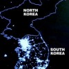
North Korea’s “Real” Potemkin Village
Just north of the DMZ lies Kijong-dong, an apparently bustling town within view of South Korean soldiers and tourists. Except this town has no residents, and the houses have no furniture, and apparently the buildings have no glass on the windows. It’s purpose appears to be propagandistic: it was built just after the war, apparently to lure South Korean sentinels across the border. Kijong-dong is a Potemkin village more real than the metaphor’s apocryphal source. And no one gets to live in a Potemkin village.

Dailypropaganda.com

“The Hotel of Doom”
No one gets to stay in the Ryugyong Hotel either; no one ever has. It’s been 25 years.

The hotel was begun in 1987. Given its setting and mandate, its semiotic function (that is, beside just lodging and making money in some fashion) is clear. It’s huge (105 stories, 3,900,000 square feet). But construction stalled more than once, famine took hold, and for more than 15 years the Pyongyang skyline featured this pyramidal windowless derelict.

Wikimedia Commons

But construction (after a fashion) resumed in 2008, thanks to a foreign investor that’s also engaged in creating North Korea’s cellular data network. Work on the exterior and cladding is complete; though it remains dark, the Ryugyong is no longer windowless.

While a bit hysterical, I have a morbid fascination with Esquire’s formulation, “The Hotel of Doom”. Well, perhaps these changes will be more than superficial. The new angel is an Egyptian telecom, Orascom.. According to The Independent:

It would cost up to $2bn (£1bn) to finish the Ryugyong Hotel and make it safe, according to estimates in South Korea’s media. That is equivalent to about 10 per cent of the North’s annual economic output. Bruno Giberti, the associate head of California Polytechnic State University’s department of architecture, said the project was typical of what has been produced recently by many cities which were trying to show their emerging wealth by constructing gigantic edifices that were not related in scale to anything else around them.

When Dubai ran into trouble, Burj Dubai became Burj Khalifa after Abu Dhabi bailed Dubai out. Perhaps we’ll end up with an empty but at least covered Hotel Sawiris?

Are They Serious?

“Who knows does not speak / who speaks does not know”–this blog included (here I am, speaking, after all). What we do know is that the imagery we do see of swooning mourners gnashing teeth is almost entirely from Pyongyang–and merely living in Pyongyang affords a North Korean a degree of privilege and comfort not available elsewhere.. And while the crowds may seem huge, there’s a substantial bit of looping involved.

The article cites B.R. Meyers on the histrionics issue. Listen to an interview with him on the topic at NPR.

This whole wailing and carrying on is really a propaganda exercise in its own right. It’s meant to convey not just the message that these people loved their leader but also the message that this is a uniquely vulnerable child race whose emotions run deeper than the emotions of people in other countries. And they’re faking a very infantile kind of grief.

[youtube]http://www.youtube.com/watch?v=dowA-daEESQ[/youtube]

In the interview, Meyers asserts that the eldest Kim’s doctrine of “juche” (akin to self reliance) is a fraud. Indeed, from nuclear extortion in exchange for financial aid and heavy fuel oil to pleas for food aid (these are legitimate in that famine is a real problem for North Koreans–though not so much for the ones we see wailing on TV), passing the hat and blackmail are a means of getting the things that would allow an even slightly more open country to maintain legitimacy.

The Daily NK reported that mourners who were judged to have been “insincere” were being sent to labor camps:

The authorities are handing down at least six months in a labor-training camp to anybody who didn’t participate in the organized gatherings during the mourning period, or who did participate but didn’t cry and didn’t seem genuine.

That report has been officially denied, having a statement be declared “official” isn’t exactly a credibility-enhancer.

“Pyongyang-ology”
It’s the new “Kremlinology” (referencing the Cold War discipline of analyzing any trace of information leaking from the USSR–particularly photography–to get clues of who might be favored by whom by inference of who’s standing next to Krushchev at a May Day parade). Similarly with North Korea, ever since Kim Jong-un was elevated to general status ahead of and named to vice-chair to the Central Military Committee ahead of the 2010 Worker’s Party of Korea conference, the “who is standing next to him” question has been vital. Kim’s uncle Jang Song Thaek not only scores high on the proximity scale but also first appeared in military uniform in those photos. Ri Yong Ho (Army Chief of Staff) is one of the runners-up.

(Edited versions courtesy of NYT's The Lens

Though most probably this photo was altered for aesthetic reasons, it brings to mind the Stalin-era alteration of photos to remove those no longer in favor (or worse). Much ink has been spilled on this topic; this article from the Hoover Institution summarizes it nicely.

Stalin and Yerzhov

Stalin sans Yerzhov

Condolences
Clues of political positioning are also given by watching who has offerred condolences, and what form they took. Even a local news weatherman may get to sign autographs at a county fair, mind you.

From the US, Bill Richardson and Jimmy Carter both offered condolences (as private citizens); there wasn’t any official condolence. Perhaps interestingly, the UN has been to the impromptu memorial at the DPRK mission to the UN, and the UN HQ in Pyongyang flew their flag at half-staff. Ban Ki-moon also offered condolences,but to the people of North Korea, not the government. It’s an important distinction, akin to Obama’s messages to the *people* of Iran. I’m fond of this quote in Foreign Policy:

‘This case is unique,’ a senior U.N. official explained to Turtle Bay. “Everything in that country is unique. I can’t think of another country where the head of state is permanently dead.” (the eldest Kim is constitutionally declared to be North Korea’s “Eternal President”)

Scott Snyder of CFR has a nice list of events to watch for (in coming months and in general) that might offer clues as far as the hardiness of Kim Jong-un’s succession.

Glimpses
“Bonus” is Gestaltist code for “I am tired of writing” and/or “I have to go for now”. So, a bonus on this topic, a few links of photos from glimpses inside North Korea.

From the Boston Globe’s phenomenal Big Picture blog:

Reuters / Nir Elias

“Land of No Smiles”: from Foreign Policy:

Tomas van Houtryve

http://publicintelligence.net/north-korea-and-the-strangest-show-on-earth/

http://www.telegraph.co.uk/news/picturegalleries/worldnews/8972862/Satellite-images-of-North-Korea-give-a-rare-glimpse-of-life-under-Kim-Jong-il.html

Read full story Comments { 0 }
Forever Overhead: GPS and Everyphone

Forever Overhead: GPS and Everyphone


KAL 007
In 1983, Soviet fighters detected and shot down a large jet they may have believed was a US RC-135 reconnaissance aircraft–it wasn’t; it was Korean Airlines flight 007–all 269 passengers and crew were killed,including an American Congressman. As well as the RC-135 that was in the air that night, a number of carrier-launched reconnaissance aircraft had been overflying Soviet installations on the Kurile Islands for months as part of the naval component of the notorious NATO operation ABLE ARCHER 83. In Presidential lore, Reagan’s emotional reaction is said to have led to the declassification of GPS in 1983. Ostensibly, he believed that access to these positioning data could be prevent the sort of straying that led to the KAL 007 incident. This sort of emotional response and its ramifications might seem a bit far-fetched, but given his Reagan’s reaction to the TV movie “The Day After” might be less surprising (let’s not forget his zealous pursuit of comprehensive arms control):

Edmund Morris, Reagan’s official biographer, said the film left Reagan “dazed” and produced the only admission he could find in Reagan’s papers that he was “greatly depressed.” Four days later, he said, Reagan was “still fighting off the depression caused by The Day After. (David Hoffman, The Dead Hand p. 91)

The trajectory of KAL 007 into Soviet airspace (CIA)


Incidentally, KAL 007 is hardly the only accidental shoot down of a commercial aircraft to have geopolitical significance. Indeed, less than five years later the USS Vicennes would shoot down Iran Air flight 655 (while in Iran’s territorial waters; the plane was also over Iranian territory).

GPS Goes Public
This isn’t the beginning of GPS’s story, but it is a seminal point in public access to the network. The Defense Department’s NAVSTAR GPS program began in 1973, and the first satellite was launched in 1978he though the system was made public in 1983, it was not completed until 1993-995 (the network comprises–among other Earthbound parts of the system–24 1-ton satellites, though the original number was 11, then 18; the full 18 were up in 1985–these were the Block I set, the full 24 were part of the Block II program). There’s significant nuance to the dates, generation and number of the satellites that I’m glossing over here on my way to the point; the Wikipedia article is actually quite comprehensive .

Everyphone
Initially, GPS receivers were restricted to auto-bound or handheld devices used by more serious trekkers, eventually a more commodity-level rental car add-on, and now a normal component of the typical smartphone.

Earlier this year, it was revealed that the iPhone was storing the phone’s location data and even sending it periodically to Apple. Note that these were not actually GPS data but locations derived from cell towers and wi-fi hotspots. Apple’s response was that the data were anonymous and used to optimize services based on these data. One problem was the length of time the data were being stored (a year) and the fact that the file was unencrypted. This was addressed soon after by an iPhone firmware update; now the information is only stored for a week (this is, incidentally, not unique to the iPhone–Android captures these data as well). There was at least one successful case of the issue being taken to court in Korea.

This exposure was made by Alasdair Allen and Pete Warden. Somewhat balancing the Foucauldian power relationship, they released an application that would allow users to see these data on a visual map. To be honest, making lemonade until the firmware update I quite enjoyed looking at the data as a sort of Situationist memory device.

Personal trajectory

I also managed to get to... well, see for yourself

The first image hews clearly to the freeways of the Bay Area. Closer zooming gives you a clear enough matrix of locations that you could perhaps trace the streets of San Francisco without the underlaid map. Which reminds me not only of the previously-mentioned North Korea image but also the signature left by a number of cabs trawling the streets of SF via Stamen’s old Cabspotting webapp (good gravy, that was 2006!):

cabspotting.org


Panopticon 2.0
(as in Web 2.0–as in the user-contributed content sense)
I was meaning here to invoke check-ins on Facebook and the like via location-aware mobile devices. Looking up Foursquare, I find out they’re not without a sense of humor (or perhaps–unlike the 90s when I was apparently cleverer–the obvious)–I’ve now realized not so clever or cynical, as it was my own confused Googling. Still:

An amusing accident...


Crowdflow.net produced a wonderful visualization of the movement of 880 iPhones in Europe this April (submitted willingly of course!) I find it oddly similar–when not in motion–to the satellite image of North vs. South Korea at night posted in a prior Forever Overhead:

[youtube]http://www.youtube.com/watch?v=EI7yQnRy7QQ[/youtube]

And of course more conventionally, GPS data have been used for years to track the movements of criminals via anklets and other penal jewelry. The Atlantic has a wonderful article on this contemporary Panopticon.

Reagan’s original statement on KAL 007:

[youtube]http://www.youtube.com/watch?v=DTumUgLLyL0[/youtube]

Read full story Comments { 0 }
Forever Overhead: North Korea

Forever Overhead: North Korea

What we see of North Korea we see mostly from without; what we see from within we glean from stolen glimpses or staged and supervised displays of “everyday life”. As a result, our most reliable vantage point may be from above.


“Dark DPRK”
It’s almost obligatory, but here’s our curtain-raiser. I’m most fond of the version without outlines, because if you know what you’re looking at, the absence of light (save for Pyongyang) makes a negative border of North Korea, especially in contrast to South Korea’s island of light below.

Crowdsourcing Surveillance
Curtis Melvin’s “North Korea Uncovered” project is a stunning manifestation of the “forever overhead” thesis. Melvin et al. compile information from myriad sources and label everything they can (prison camps, ostrich farms, nuclear facilities, and Kim Jong-Il’s Neverland-esque water slide)–NoKo-spotting. They’re private analysts somewhat obsessively aggregating a rather serious open-source intelligence resource. Crowdsourcing it, actually: journalists, historians, retired CIA analysts have all contributed. And they’re “just” citizens–anyone with an Internet connection could do this… but now, we can just download the Google Earth KMZ file.

Nukes From Above (Still Lifes, Fortunately)
The Institute for Science and International Security has been acquiring commercial satellite imagery and reporting on the growth of the nuclear facilities at Yongbyon (the last update was yesterday). NKeconwatch has archives of past reports going back to 2008.

While we’re exploring the intersection of the Yongbyon facility and the Forever Overhead topic, a few years ago (2007, when Yongbyon was ostensibly inactive as part of the six-party talks) Satellite Imaging Corporation put together a fun 3D “flythrough” of the compound.

[youtube]http://www.youtube.com/watch?v=x34Y7iZqqEo[/youtube]

Speaking of supervised glimpses inside, IAEA inspections in 2008 to verify the aforementioned shutdown and accounting for all active and spent fuel (as in not being diverted) brought us this raw footage from inside Yongbyon. Note the ubiquitously-paired portraits of Il-Sung and Jong-Il in the control room.

Let’s not forget that the DPRK can exploit our dependence on overhead intelligence to telegraph its intentions (or attempt to get negotiating leverage) as far as nuclear tests; we had news reports based on satellite reconnaissance that North Korea might be preparing to test in May 2005, October 2006 (this one of course did culminate in an actual test), May 2009 (also “true”), even October 2010. Efforts to spoof aerial reconnaissance date back to WWI, but that topic awaits a future post. Of course, one doesn’t need to confine themselves to mere telegraphy, they can always just announce their intentions outright.

Also, back on the topic of judging growth at a distance, Amnesty International has made comparisons of overhead imagery to expose North Korea’s prison camps and the growth thereof.

A Note On Food Aid
Food–particularly the absence of it–is a perennial issue. The 1990s famine . North Koreans men are, on average, shorter than their South Korean counterparts. A US government team is currently in North Korea investigating claims that a new food crisis is underway and whether new requests for aid are founded. There is little doubt that North Koreans are indeed starving; the problem is that the DPRK has a history of “food deceit”, diverting international aid resources, to support its missile and nuclear programs. Food aid to North Korea should be closely monitored and contingent on rejoining–in “good faith”–talks with Le Six.

And missiles. And rockets.

AP (Digitalglobe)

Another Note on Stolen Glimpses: “Traffic Ladies”
Speaking of stolen glimpses, this is as fine an opportunity as any to mention the “traffic ladies” of Pyongyang (apparently an easy glimpse to steal, given the ubiquity of clips on YouTube–the only reason it took me more than 30 seconds to locate one to share was finding one without a lame sexist title):

[youtube]http://www.youtube.com/watch?v=hDHhW5_RxKc[/youtube]

Postscript: Syria/Al-Kibar
I’m out of juice, but you may remember the Osirak-reverie-inducing destruction of the putative reactor in Syria in . Alas, I’m out of steam and heading out, so for now you’ll have to settle for the company line:

[youtube]http://www.youtube.com/watch?v=4ah6RmcewUM[/youtube]

Al-Kibar Before/After

Read full story Comments { 3 }
Forever Overhead: Pakistan

Forever Overhead: Pakistan

Drones, reactors, floods, and Usama bin Laden’s Google Earth debut–and you don’t have to work for a covert agency to see (most of) them…

Drones
The official US position on drone strikes in Pakistan is that they are “cross-border”, i.e. launched from bases in Afghanistan. However, Google Earth images obtained in 2009 by Pakistan’s The News and The London Times clearly showed Predator drones at Shamsi airfield North of Quetta. Denials were more pointed after an unwitting “outing”/mistake by Senator Feinstein when she said at a hearing (also in 2009), “As I understand it, these are flown out of a Pakistani base”. Her office attempted to walk the utterance back as well.

The aircraft are of course no longer visible on Google Earth, though new structures have since appeared. Ogleearth has a fairly enjoyable speculation and wonderment-rich post on the provenance of the images.

New America Foundation maintains a marvelous visualization/Google Maps mashup of drone strikes on Pakistani territory, with all available supplemental data on location/combatant vs. civilian casualties, etc. 2004-present.

Our study shows that the 244 reported drone strikes in northwest Pakistan, including 31 in 2011, from 2004 to the present have killed approximately between 1,493 and 2,379 individuals, of whom around 1,200 to 1,908 were described as militants in reliable press accounts. Thus, the true non-militant fatality rate since 2004 according to our analysis is approximately 20 percent. In 2010, it was more like five percent. [As of May 27, 2011]

The Nuclear Program
Newsweek recently reported on discoveries made by examining commercially-obtained imagery of the Khushab site. The images show construction (circa April 2011) of a fourth reactor for plutonium production (via reprocessing).

Not only does this represent expansion of the program itself, but also points to yet another track for the production of nuclear material. Heretofore (really, circa 10-15 years ago) the putatively prodigious output of Pakistan’s production had been based on Highly Enriched Uranium (HEU) created in the enrichment process stolen, mastered, refined and in addition sold (sometimes in “turnkey” fashion including not just plans and the like but access to networks of businessmen who could illicitly provide the makings of similar programs)–thanks to the strikingly James Bond-bad guy-like A.Q. Khan–to a rogue’s gallery of countries including North Korea, Iran (where the P-1 became the Ir-1), and Libya (which, fortunately, “came clean” and sent its centrifuges to Tennessee, where good use is apparently being made of them–I imagine at more than one point in the last month or so the Colonel has been wondering if his short-lived return from pariah status was worth it).

Now, Pakistan’s diversification from just HEU into plutonium isn’t news, but again, the high points here are the pace of expansion and, the ostensibly public nature of the imagery and discovery (though seriously, one has to wonder how closely they were led to acquire imagery at this particular time from this particular site, and by whom).

I’m not going to belabor the plausibility and nuances of the “nightmare scenario” of loose (or acquisition-abetted) nukes at this point, but I will link to Sanger/Broad’s NYT article about US efforts to assist Pakistan in securing their arsenal, going so far as to offer assistance in developing PALs (Permissive Action Links–basically, as close as you will get to the real-life version of what are colloquially referred to as “launch codes” in popular culture). One interesting International Law nuance here is the question of whether giving PALs (or even assisting in the development of the technology) to a NPT non-signatory is a violation of our obligations under article 1 of said treaty.

Darn it, I was looking to some more canonical source, but the Wikipedia entry on PALs is pretty good.

Floods
Courtesy of NASA we have some astonishing imagery which brings home the scope of destruction of the 2010 flooding in the districts around the Indus River. Despite being a “show, don’t tell” advocate, the stats are hard to resist.

  • Approximately 1800 killed, BUT ~20 MILLION impacted
  • 1.5M displaced
  • 1.89M homes destroyed
  • An estimated $500 million crop damage (and of course let’s remember that you needn’t be anywhere near the vicinity of the flooding to be impacted by the absence of the food derived from those crops)
  • 5.3M jobs lost or attenuated, total economic impact estimated $43B; Pakistan’s GDP dropped or will bottom out 6-9% lower (obviously, taking us well into negative growth)

One unfortunately strategic beneficiary might be the Tehrik-i-Taliban Pakistan (TTP, AKA “The Pakistani Taliban”), as they were able to provide assistance where the government couldn’t; this affords them a source of legitimacy they don’t normally pursue, more in the manner of Hizbullah in Southern Lebanon (which provides civil services there in absence–sometimes ensuring it–of the government; this is why you may sometimes hear Southern Lebanon referred to as “a state within a state”). As a result we have “inverse counterinsurgency” and a can count a strengthened TTP as one result of the floods. Also, government forces were distracted from their counter-TTP efforts by the floods.

Usama bin Laden Makes the Google Earth Scene
Some will remember a prior Contours of Catastrophe post musing about the familiarity of the outline of bin Laden’s compound. Well, the entrenchment of the shape and relevance of Google Earth continues apace–per geography.pk:

A milestone, all thanks to Bin Laden’s death perhaps that Google has “pre-announced” satellite imagery update for first time ever. This imagery update as expected includes the updated imagery for Abbottabad town of Pakistan that has gained attentions in recent days.

Read full story Comments { 0 }