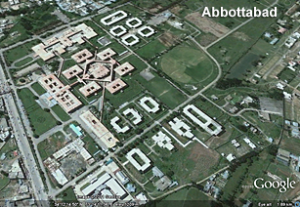
Drones, reactors, floods, and Usama bin Laden’s Google Earth debut–and you don’t have to work for a covert agency to see (most of) them…
Drones
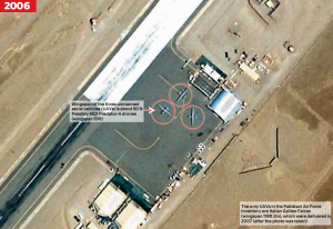
The official US position on drone strikes in Pakistan is that they are “cross-border”, i.e. launched from bases in Afghanistan. However, Google Earth images obtained in 2009 by Pakistan’s The News and The London Times clearly showed Predator drones at Shamsi airfield North of Quetta. Denials were more pointed after an unwitting “outing”/mistake by Senator Feinstein when she said at a hearing (also in 2009), “As I understand it, these are flown out of a Pakistani base”. Her office attempted to walk the utterance back as well.
The aircraft are of course no longer visible on Google Earth, though new structures have since appeared. Ogleearth has a fairly enjoyable speculation and wonderment-rich post on the provenance of the images.
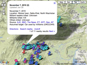
New America Foundation maintains a marvelous visualization/Google Maps mashup of drone strikes on Pakistani territory, with all available supplemental data on location/combatant vs. civilian casualties, etc. 2004-present.
Our study shows that the 244 reported drone strikes in northwest Pakistan, including 31 in 2011, from 2004 to the present have killed approximately between 1,493 and 2,379 individuals, of whom around 1,200 to 1,908 were described as militants in reliable press accounts. Thus, the true non-militant fatality rate since 2004 according to our analysis is approximately 20 percent. In 2010, it was more like five percent. [As of May 27, 2011]
The Nuclear Program
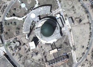
Newsweek recently reported on discoveries made by examining commercially-obtained imagery of the Khushab site. The images show construction (circa April 2011) of a fourth reactor for plutonium production (via reprocessing).
Not only does this represent expansion of the program itself, but also points to yet another track for the production of nuclear material. Heretofore (really, circa 10-15 years ago) the putatively prodigious output of Pakistan’s production had been based on Highly Enriched Uranium (HEU) created in the enrichment process stolen, mastered, refined and in addition sold (sometimes in “turnkey” fashion including not just plans and the like but access to networks of businessmen who could illicitly provide the makings of similar programs)–thanks to the strikingly James Bond-bad guy-like A.Q. Khan–to a rogue’s gallery of countries including North Korea, Iran (where the P-1 became the Ir-1), and Libya (which, fortunately, “came clean” and sent its centrifuges to Tennessee, where good use is apparently being made of them–I imagine at more than one point in the last month or so the Colonel has been wondering if his short-lived return from pariah status was worth it).
Now, Pakistan’s diversification from just HEU into plutonium isn’t news, but again, the high points here are the pace of expansion and, the ostensibly public nature of the imagery and discovery (though seriously, one has to wonder how closely they were led to acquire imagery at this particular time from this particular site, and by whom).
I’m not going to belabor the plausibility and nuances of the “nightmare scenario” of loose (or acquisition-abetted) nukes at this point, but I will link to Sanger/Broad’s NYT article about US efforts to assist Pakistan in securing their arsenal, going so far as to offer assistance in developing PALs (Permissive Action Links–basically, as close as you will get to the real-life version of what are colloquially referred to as “launch codes” in popular culture). One interesting International Law nuance here is the question of whether giving PALs (or even assisting in the development of the technology) to a NPT non-signatory is a violation of our obligations under article 1 of said treaty.
Darn it, I was looking to some more canonical source, but the Wikipedia entry on PALs is pretty good.
Floods
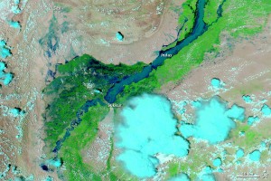
Courtesy of NASA we have some astonishing imagery which brings home the scope of destruction of the 2010 flooding in the districts around the Indus River. Despite being a “show, don’t tell” advocate, the stats are hard to resist.
- Approximately 1800 killed, BUT ~20 MILLION impacted
- 1.5M displaced
- 1.89M homes destroyed
- An estimated $500 million crop damage (and of course let’s remember that you needn’t be anywhere near the vicinity of the flooding to be impacted by the absence of the food derived from those crops)
- 5.3M jobs lost or attenuated, total economic impact estimated $43B; Pakistan’s GDP dropped or will bottom out 6-9% lower (obviously, taking us well into negative growth)
One unfortunately strategic beneficiary might be the Tehrik-i-Taliban Pakistan (TTP, AKA “The Pakistani Taliban”), as they were able to provide assistance where the government couldn’t; this affords them a source of legitimacy they don’t normally pursue, more in the manner of Hizbullah in Southern Lebanon (which provides civil services there in absence–sometimes ensuring it–of the government; this is why you may sometimes hear Southern Lebanon referred to as “a state within a state”). As a result we have “inverse counterinsurgency” and a can count a strengthened TTP as one result of the floods. Also, government forces were distracted from their counter-TTP efforts by the floods.
Usama bin Laden Makes the Google Earth Scene
Some will remember a prior Contours of Catastrophe post musing about the familiarity of the outline of bin Laden’s compound. Well, the entrenchment of the shape and relevance of Google Earth continues apace–per geography.pk:
A milestone, all thanks to Bin Laden’s death perhaps that Google has “pre-announced” satellite imagery update for first time ever. This imagery update as expected includes the updated imagery for Abbottabad town of Pakistan that has gained attentions in recent days.


