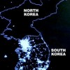
Tag Archives: Google Earth
Forever Overhead: North Korea

Forever Overhead: North Korea

What we see of North Korea we see mostly from without; what we see from within we glean from stolen glimpses or staged and supervised displays of “everyday life”. As a result, our most reliable vantage point may be from above.


“Dark DPRK”
It’s almost obligatory, but here’s our curtain-raiser. I’m most fond of the version without outlines, because if you know what you’re looking at, the absence of light (save for Pyongyang) makes a negative border of North Korea, especially in contrast to South Korea’s island of light below.

Crowdsourcing Surveillance
Curtis Melvin’s “North Korea Uncovered” project is a stunning manifestation of the “forever overhead” thesis. Melvin et al. compile information from myriad sources and label everything they can (prison camps, ostrich farms, nuclear facilities, and Kim Jong-Il’s Neverland-esque water slide)–NoKo-spotting. They’re private analysts somewhat obsessively aggregating a rather serious open-source intelligence resource. Crowdsourcing it, actually: journalists, historians, retired CIA analysts have all contributed. And they’re “just” citizens–anyone with an Internet connection could do this… but now, we can just download the Google Earth KMZ file.

Nukes From Above (Still Lifes, Fortunately)
The Institute for Science and International Security has been acquiring commercial satellite imagery and reporting on the growth of the nuclear facilities at Yongbyon (the last update was yesterday). NKeconwatch has archives of past reports going back to 2008.

While we’re exploring the intersection of the Yongbyon facility and the Forever Overhead topic, a few years ago (2007, when Yongbyon was ostensibly inactive as part of the six-party talks) Satellite Imaging Corporation put together a fun 3D “flythrough” of the compound.

[youtube]http://www.youtube.com/watch?v=x34Y7iZqqEo[/youtube]

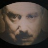
Speaking of supervised glimpses inside, IAEA inspections in 2008 to verify the aforementioned shutdown and accounting for all active and spent fuel (as in not being diverted) brought us this raw footage from inside Yongbyon. Note the ubiquitously-paired portraits of Il-Sung and Jong-Il in the control room.

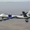
Let’s not forget that the DPRK can exploit our dependence on overhead intelligence to telegraph its intentions (or attempt to get negotiating leverage) as far as nuclear tests; we had news reports based on satellite reconnaissance that North Korea might be preparing to test in May 2005, October 2006 (this one of course did culminate in an actual test), May 2009 (also “true”), even October 2010. Efforts to spoof aerial reconnaissance date back to WWI, but that topic awaits a future post. Of course, one doesn’t need to confine themselves to mere telegraphy, they can always just announce their intentions outright.

Also, back on the topic of judging growth at a distance, Amnesty International has made comparisons of overhead imagery to expose North Korea’s prison camps and the growth thereof.

A Note On Food Aid
Food–particularly the absence of it–is a perennial issue. The 1990s famine . North Koreans men are, on average, shorter than their South Korean counterparts. A US government team is currently in North Korea investigating claims that a new food crisis is underway and whether new requests for aid are founded. There is little doubt that North Koreans are indeed starving; the problem is that the DPRK has a history of “food deceit”, diverting international aid resources, to support its missile and nuclear programs. Food aid to North Korea should be closely monitored and contingent on rejoining–in “good faith”–talks with Le Six.

And missiles. And rockets.

AP (Digitalglobe)

Another Note on Stolen Glimpses: “Traffic Ladies”
Speaking of stolen glimpses, this is as fine an opportunity as any to mention the “traffic ladies” of Pyongyang (apparently an easy glimpse to steal, given the ubiquity of clips on YouTube–the only reason it took me more than 30 seconds to locate one to share was finding one without a lame sexist title):

[youtube]http://www.youtube.com/watch?v=hDHhW5_RxKc[/youtube]

Postscript: Syria/Al-Kibar
I’m out of juice, but you may remember the Osirak-reverie-inducing destruction of the putative reactor in Syria in . Alas, I’m out of steam and heading out, so for now you’ll have to settle for the company line:

[youtube]http://www.youtube.com/watch?v=4ah6RmcewUM[/youtube]

Al-Kibar Before/After

Read full story Comments { 3 }
Forever Overhead: Pakistan

Forever Overhead: Pakistan

Drones, reactors, floods, and Usama bin Laden’s Google Earth debut–and you don’t have to work for a covert agency to see (most of) them…

Drones
The official US position on drone strikes in Pakistan is that they are “cross-border”, i.e. launched from bases in Afghanistan. However, Google Earth images obtained in 2009 by Pakistan’s The News and The London Times clearly showed Predator drones at Shamsi airfield North of Quetta. Denials were more pointed after an unwitting “outing”/mistake by Senator Feinstein when she said at a hearing (also in 2009), “As I understand it, these are flown out of a Pakistani base”. Her office attempted to walk the utterance back as well.

The aircraft are of course no longer visible on Google Earth, though new structures have since appeared. Ogleearth has a fairly enjoyable speculation and wonderment-rich post on the provenance of the images.

New America Foundation maintains a marvelous visualization/Google Maps mashup of drone strikes on Pakistani territory, with all available supplemental data on location/combatant vs. civilian casualties, etc. 2004-present.

Our study shows that the 244 reported drone strikes in northwest Pakistan, including 31 in 2011, from 2004 to the present have killed approximately between 1,493 and 2,379 individuals, of whom around 1,200 to 1,908 were described as militants in reliable press accounts. Thus, the true non-militant fatality rate since 2004 according to our analysis is approximately 20 percent. In 2010, it was more like five percent. [As of May 27, 2011]

The Nuclear Program
Newsweek recently reported on discoveries made by examining commercially-obtained imagery of the Khushab site. The images show construction (circa April 2011) of a fourth reactor for plutonium production (via reprocessing).

Not only does this represent expansion of the program itself, but also points to yet another track for the production of nuclear material. Heretofore (really, circa 10-15 years ago) the putatively prodigious output of Pakistan’s production had been based on Highly Enriched Uranium (HEU) created in the enrichment process stolen, mastered, refined and in addition sold (sometimes in “turnkey” fashion including not just plans and the like but access to networks of businessmen who could illicitly provide the makings of similar programs)–thanks to the strikingly James Bond-bad guy-like A.Q. Khan–to a rogue’s gallery of countries including North Korea, Iran (where the P-1 became the Ir-1), and Libya (which, fortunately, “came clean” and sent its centrifuges to Tennessee, where good use is apparently being made of them–I imagine at more than one point in the last month or so the Colonel has been wondering if his short-lived return from pariah status was worth it).

Now, Pakistan’s diversification from just HEU into plutonium isn’t news, but again, the high points here are the pace of expansion and, the ostensibly public nature of the imagery and discovery (though seriously, one has to wonder how closely they were led to acquire imagery at this particular time from this particular site, and by whom).

I’m not going to belabor the plausibility and nuances of the “nightmare scenario” of loose (or acquisition-abetted) nukes at this point, but I will link to Sanger/Broad’s NYT article about US efforts to assist Pakistan in securing their arsenal, going so far as to offer assistance in developing PALs (Permissive Action Links–basically, as close as you will get to the real-life version of what are colloquially referred to as “launch codes” in popular culture). One interesting International Law nuance here is the question of whether giving PALs (or even assisting in the development of the technology) to a NPT non-signatory is a violation of our obligations under article 1 of said treaty.

Darn it, I was looking to some more canonical source, but the Wikipedia entry on PALs is pretty good.

Floods
Courtesy of NASA we have some astonishing imagery which brings home the scope of destruction of the 2010 flooding in the districts around the Indus River. Despite being a “show, don’t tell” advocate, the stats are hard to resist.

  • Approximately 1800 killed, BUT ~20 MILLION impacted
  • 1.5M displaced
  • 1.89M homes destroyed
  • An estimated $500 million crop damage (and of course let’s remember that you needn’t be anywhere near the vicinity of the flooding to be impacted by the absence of the food derived from those crops)
  • 5.3M jobs lost or attenuated, total economic impact estimated $43B; Pakistan’s GDP dropped or will bottom out 6-9% lower (obviously, taking us well into negative growth)

One unfortunately strategic beneficiary might be the Tehrik-i-Taliban Pakistan (TTP, AKA “The Pakistani Taliban”), as they were able to provide assistance where the government couldn’t; this affords them a source of legitimacy they don’t normally pursue, more in the manner of Hizbullah in Southern Lebanon (which provides civil services there in absence–sometimes ensuring it–of the government; this is why you may sometimes hear Southern Lebanon referred to as “a state within a state”). As a result we have “inverse counterinsurgency” and a can count a strengthened TTP as one result of the floods. Also, government forces were distracted from their counter-TTP efforts by the floods.

Usama bin Laden Makes the Google Earth Scene
Some will remember a prior Contours of Catastrophe post musing about the familiarity of the outline of bin Laden’s compound. Well, the entrenchment of the shape and relevance of Google Earth continues apace–per geography.pk:

A milestone, all thanks to Bin Laden’s death perhaps that Google has “pre-announced” satellite imagery update for first time ever. This imagery update as expected includes the updated imagery for Abbottabad town of Pakistan that has gained attentions in recent days.

Read full story Comments { 0 }
Forever Overhead: Panopticon 2.0

Forever Overhead: Panopticon 2.0

Seeing is knowledge is power…


Panopticon, USA
Simplistic to be sure, but one could do worse if pressed for Foucault in five words. Knowledge and power are inextricably entwined, and seeing confers knowledge. Foucault made a trope of Jeremy Bentham’s architectural model, the Panopticon, to embody the role of observation in power relations. The Panopticon centralizes and privileges seeing; because everyone is a potential subject, they become an object of passive cohersion. In a prison designed on this model, the warden, situated in a central tower, could see every prisoner; since no one could be certain whether they were the focus of his gaze, they would regulate their own behavior, almost constantly, without active cohersion (discipline)–in fact, no one need be watching at all (the shelf life of this would, of course, be limited!): the mere threat of being observed would suffice.

Bentham's Panopticon (Wikimedia Commons)

…it is at once too much and too little that the prisoner should be constantly observed by an inspector: too little, for what matters is that he knows himself to be observed; too much, because he has no need in fact of being so. In view of this, Bentham laid down the principle that power should be visible and unverifiable. Visible: the inmate will constantly have before his eyes the tall outline of the central tower from which he is spied upon. Unverifiable: the inmate must never know whether he is being looked at at any one moment; but he must be sure that he may always be so. (Foucault, page 201 in the Vintage edition of Discipline & Punish)

The Threat of Visibility
But far more than just the person, the body, can be seen and confer power–all the traces of our lives have this capacity. For example, the immense trove of knowledge (films, photos, wiretaps, recovered mail, even gossip) that J. Edgar Hoover hoarded furthers the possibilities of passive cohersion, and couples control with reconnaisance. The fact that this hoard existed was an open secret, and no one, not even–especially not–the president was immune; any aspect of anyone’s “private” life might be exploited by Hoover or those he deigned to share scraps of this power with. Anyone who knew this might moderate their own behavior lest traces be sucked up by Hoover’s “Hoover”. Failing that, their only recourse would be to carefully manage their relationship with the FBI Director (not the office, but the Director himself).

Information Wants To Be Free
But, in the words of Stewart Brand, “Information wants to be free” (though originally he meant this in terms of expense, not liberation), and apparently it also seeks to liberate itself. And so, with for instance Google Maps/Earth/Street View, we become our own warden. Increasingly there is no single, centralized warden: less and less information is the exclusive property of state-operated agencies (to some degree–what’s worthy of exposé may not be sufficient to locate and destroy Usama bin Laden, for instance). Now anyone, given sufficient means, can acquire commercial satellite imagery (there was a time when the idea of commoditizing these images was contentious–indeed, how much longer will drones remain the sole province of state-run agencies?), or just find it on Google Earth and gain some knowledge worthy of exposure.

Google Street View

Panopticon Now
The contemporary Panopticon is not merely a penal device; not only is it a ubiquitous source of institutional intrusion, it’s also a framework for entertainment:

  • Workplace email
  • A Supreme Court nominee’s video rentals
  • Non-cash transaction records
  • Facebook (where we all can watch each other, for fun!)
  • Location check-in apps (wave to the Panopticon!)
  • Google dependency
  • iPhone GPS data storage.

Google Street View

But in popular culture it’s a trope all its own: reality TV (indeed, one of the progenitors of the genre was called “Big Brother”), protagonist/antagonist relationships throughout drama (think Klute, or the classic Lifetime drama, the Eye of Sauron, Rear Window–or just about anything, really).

However, for the purposes of this series, I’ll just focusing on the overhead manifestations, particularly the “democratizing” ones. Satellites, drones, and other forms of aerial sensing might be considered a sort of vertical Panopticon.

Read full story Comments { 0 }